Road Pad for Android
by Robosoul
Version 1.3.1 💾 2 Mb
📅 Updated March 2, 20

Features Road Pad for Android
- View a satellite image of any road or junction and use the built-in drawing tool to illustrate the image and instruct your pupil.- Save your most commonly used images so they can be retrieved immediately, even when your network connection is slow or unavailable.
- Help your pupils to learn exactly what they should be doing in any given situation.
- Also provided is a blank drawing pad so you can easily illustrate anything that comes to mind.
How it works:
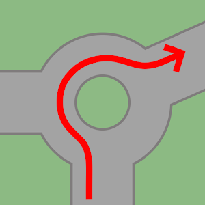
Your pupil has just made a meal of a large roundabout.
You pull over to the side of the road and open Road Pad.
Select the Map view and Road Pad will zoom in on your current position.
Then simply pan the image over the roundabout, tap the draw button, and start illustrating how it should be done.
It's that easy!
If there are particular roads or junctions you find you need to illustrate regularly, these can be cached in your library for quick retrieval - regardless of network availability.
Steve Hilton has developed the Android version in consultation with Neil Beaver, the ADI behind the the original iPad app.
Please be aware: NO GUARANTEES CAN BE MADE ABOUT THE QUALITY OR RESOLUTION OF SATELLITE IMAGES IN YOUR AREA.
Location services and ability to download satellite images are dependent on a suitable network connection being available.
Social Features
Connect and share with friends and the community.
Learning Tools
Enhance your learning experience with interactive features.
Offline Mode
Use the app without an internet connection. Your data syncs when you're back online.
See the Road Pad for Android in Action


Get the App Today
Available for Android 8.0 and above